Monthly Archives: July 2016

Continuing South


Sunrise in the Lee Metcalf wilderness, Spanish Peaks division – like a mini Sierra


Our journey starts to lose coherence. The routes are unraveling as we move south, road walking into Ennis, hitching out, road walking, bridge jumping, running out of food and water – but everything is fine. This is who we are; slightly fractured humans attempting to assemble a meaningful narrative from seemingly disparate parts. Traversing the unknown is always a roll of the dice (thanks Mallarmé for that), but the payout is great at 1000 to 1. So sitting here in Yellowstone after too man miles and not enough food, surrounded by American car culture, sugar crazed kids, foreign tongues and unexpected thunder storms everything is as it should be…  

The border of Yellowstone national park at the north west intersection with the Skyline trail

Harpo headed thru the cut on the Sportsman Lake trail, Yellowstone


Disnyfied natural attractions in Mammoth, Yellowstone


the view from the top – well worth the 6000 feet vertical gain for the day


Big Sky Horizons


img_2127

Morning sage & hot coffee ritual at abandoned Nicholson Mine

img_2130

Greetings from Poop Joke Pass. There’s no name on the map so we christened it…

img_2145

Coming down the road to Ennis Lake, our first glimpse of the Spanish Peaks

img_2148

I don’t even know what this means…

img_2112

Pollen party!


img_2077
Another sunset! Tobacco Root Mountains…


Where Adventure Begins

  
Despite the negative feedback we’ve received concerning our route choice – deviating from the ‘actual’ divide trail for another alternate – we’ve also got some real positive messages (thanks!). The reality is sinking in – we’re off trail and relying only on our own abilities to create and survive this new route. No red line, no water or resupply or milage data, no northbounders to ask about tips. Only topo maps and a couple of anecdotal examples guide us. It’s awesome.

Also terrifying. We’ve talked at length about how thru hiking the AT & PCT were essentially urban disciplines. If one is skilled at logistics and willing to withstand some discomfort, the hiking takes care of itself. Ramen, peanut butter and Clif Bars create the illusion of wilderness, but thru hiking is essentially a life facilitated by data sets, technology, and processed food. On the surface it’s  very different from existing in the city (pooping outside!) but underneath it’s strikingly similar. Which is not to say it’s simple either…

It feels good to push beyond these boundaries. Not that we’re building deadfalls for chipmunks & tanning their hides with their own brains to make loincloths. But we’re increasing our map literacy, overcoming fears of asking for help, and trusting our intuition.

I’m a different person than I was when I began walking long trails, and this world is a long, long way from the city I’ve called home for the past 15 years, and even further from the suburbs I grew up in. It’s a world Harpo and I create and navigate together thru shared vision, integrity, honesty and sometimes a few tears. It’s not easy, but it’s certainly not boring either.

Harpo’s CDT Journal #4

July 19

Zero!!

We weren’t planning on taking a full day off so soon but I Feel ok about it because “half mile”, the famous PCT data collector, is in the hotel and HE’S Taking a double zero. 
We focus on our Big Sky routing today. First at the Fire Tower Coffee shop where we upload online maps. Gaia is an awesome $20 phone app. it comes with a global topo map with common paved roads, dirt roads and trails. The map is viewable online and you can download any sections you want for offline use. There’s another app called PDF MAPS which is free, but you have to search their database for maps you want and sometimes pay for them if they are proprietary (i.e. National geographic Etc). Like Guthook, the apps can use the gps in our phone to show us within a few meters where we are on these maps. We decide to use Gaia for help on our side trip. 
At the Base Camp Outfitter with Tim’s help  we spread maps everywhere and choose the three pictured above.

Then we eat amazing pizza at Bridge Pizza. 

Finally at the Library we print more detailed maps that other hikers (the Onion and Brian) have published of their routes thru this area. Prints are 10 cents at the library and an hour of Internet is free.

We run into Eric and Olivia, bike packers who are on the Great Divide cycle route, which is very popular but mostly follows fire and jeep roads so we only see folks at resupply stops. Eric did the documentary “Do more with less” about the PCT. the next 2 years, he and Olivia will travel 18000 miles by bicycle! They leave for India in a few weeks and are documenting their trip at ridingwild.org

We head to Real Food which lives up to its promise with fruit, vegan snacks and a killer bulk section including powdered hummus (which I will literally start adding to every meal until I run out). 
Back at the hotel, we lay out our maps comparing routes, choose a trajectory that works best for us (highlighting it in pink) and trimming off the unnecessary sections.

As we are booze free (for now!), we enjoy a nightcap of sparkling water and coconut milk Ice cream. 
July 20

15 miles
Ron, who we met on trail a few days ago, arrives in Helena and offers us a ride to the trail head before he heads home to Portland. He’s paying back all all the hitches he’s got over the years. What a swell fellow. We hope to see him in Portland!

At the trailhead we eat some fresh food we packed out then hit the trail. it’s impeccably well maintained and we easily hike 15 miles before dark. However a longish section up a forest road sports “private property” signs on every turn. We look/walk for an hour, and finally find a flat patch at the crest of a hill. Obviously not within a private property boundary but maybe next to their driveway?! Not our finest moment but dusk is upon us and we must needs sleep. 

July 21 

27 miles
Today is tough. The trail, still impeccably maintained, continues but is slightly dull. Mostly tree tunnel and a lot of half dead forest due to pine beetle. My mood mimics the melancholy of the forest. Now that we’ve chosen to do the alternate I feel anxious to get there. Get somewhere. GET ANYWHERE. 
The afternoon sun blazes thru our dusty path. We meet hikers who tell of a lake but the marshy reality thwarts our dreams of a cool swim. 
Again, it takes us a half hour to find a campsite but when we do – we find a little cozy “hole” (as Huck calls them) nestled between trees with a breathtaking Montana sunset. 


July 22

24 miles
I’m bummed. Groucho is bummed. We’re all bummed. It’s another blazing, meh day with an 18 mile waterless stretch. 
Finding camomile in a dusty patch of trail brings a sweet relief to my nerves and hiker stench. I stash a sprig in my shirt pocket to dry out.


Around 6 we track down a campground on the map – they offer well water and PICNIC TABLES. we sit. Then I really want to stay. Groucho pushes me onward. Not harder than I want to be pushed -today- but I do often feel he wants to always go just a little further… a little faster… Than I. 
We find a high forestry knoll to bed down beside a country road. We can hear the occasional boozy drivers and a random gunshot (it’s Friday night in Montana!) but they can’t see us up on the hill. 

July 23

30 miles
Today Groucho summarizes “the scenery was unremarkable, but the drama was high.”
We start with a 7 mile road walk. A bummer because pavement can bruise/wear out the feet. But miles can go faster as well. 
Then up up up 3.5 miles to our junction. THE JUNCTION. our split from the CDT and on to the Harpo and Groucho edition of the Big Sky Route. 
Okay so if I’m honest I’ll say I am amped up. I’m worried. Worried the trail junction doesn’t show up on Guthook data -so maybe we’ll miss it. Worried the mile calculations will be off and we won’t have enough food to get to Whitehall. Worried the trail will all be Blowdowns and bush whacking. Worried there won’t be water. 
With all these worries, it’s obvious I’m not worried about any of these things but rather, I’m just anxious because we’re attempting something new. And I’m assigning that anxiety to anything I can get my hands on. 
So up up up the hill we go and I ask Groucho a navigation question about if we’re coming to the trail junction, which he doesn’t seem to acknowledge. And with that, my anxiety rushes out like a kettle just come to boil “hey GROUCHO. Are you going to answer my QUESTION OR NOT” 
Super bitch move. 
Then Groucho SHOUTS back (so I can hear him presumably) the answer to my question, explaining he answered before but I didn’t hear. 
So “GREAT,” I fume to myself as he marches away. “We’re already off to a great start with this new route thing where I can’t even ask questions.”
And I stop to pee and Groucho leaves my sight. And then I come upon a junction. No Groucho. Ugh! Not this again. I think this might be THE junction because it’s at the right mileage marker but it’s not matching the map topography. Ugh. So I make my best choice and fly up the hill. Tears in my eyes, intermittently furious and also thinking maybe I just need a snack. 
You see, besides the stress of new routes and maps and tools, we are also burning 3000-4000 calories a day but I stupidly only packed 1800 Cal/day for this leg. Hiker hunger kicks in around day 20 and today – on day 21 – my baby fat reserves are almost gone. This panic might just be legitimate hunger. 
Ok so it turns out there is an error in the data set and the REAL junction is another 1.5 miles up the hill. When I arrive Groucho seems happy enough. But I have FEELINGS. I try to repress them and focus on food but then some bad communication happens and for 30 minutes we stop to discuss impressions, assumptions, blame, communication, hunger, fear, routes, empathy, protocols and defensiveness. We both feel like real adult champions, tho completely emotionally depleted. 

we finally set off the beaten CDT path and onto the Nez Perce route. 
I needn’t have worried. this trail is easy and wide and follows a creek. After 5 miles we intersect with a dusty road populated both with ATVS and REAL COWBOYS!!!
We reach delmoe lake by 5pm and wash, do laundry, eat dinner and rest for a half hour. Then we hike onward, away from the lake. 


As evening approaches more and more ATVS drive by us, blowing dust in my face and hot air up my recently cleaned skirt. 
Here, the desert-like terrain reminds me of So Cal. Cactus and prickly seed pod plants and scrubby pines and sage brush galore. 


Finally, frustrated with the dust kicked up by by weekend warriors, we walk along some adjacent abandoned railroad tracks. The boards are rotting and sage brush is thigh high in places but the romance of it thrills me. We approach a humble railroad trestle over a stream. No problem. We got this. The 12 year olds in Stand By Me handled it and so can I. Though the boards are strong and true, they groan with my first few steps. A few minutes later I begin to notice how train ties are not always evenly spaced and also not spaced for a easy human stride. I adjust. My steps grow short and precise. No problem. But then in the spaces between the wooden ties I spy glimmers of the river below. VERY FAR BELOW . My heart starts to race. My body, I’ve found, is immensely intelligent. Give it a crazy challenge and it figures out what to do, where to step, how to balance, but that tricky MIND is so dumb and gets in the way. Half way across the trestle my mind becomes convinced I will step into one of the gaps between the boards. This is inprobable but even if I DID I would trip but almost certainly not fall thru the cracks to the gully below. I know this, my feelings know this. But my MIND is so dumb. Groucho passes me on the right. I am afraid to lookup and see how many boards are left so I tell him to tell me I’m close. He says Very Close. I repeat: very close. I discover if I look 3 boards ahead I feel safer than looking at the board just below because the vertigo or whatever I’m experiencing is heightened by the light and movement of the water below. I focus three boards ahead and each step say aloud “Very Close.” Very Close. Tears shine in my eye sockets and I hold my hands aloft like a toddler. I am in a middle of a crisis. I know if i stop to look around it will get worse so I just repeat “very close. Very close. very close.” Finally. finally. I make it. 
“I am never doing that again.”
2 hours later we camp next to the tracks away from the ATVS but the glow of I90 in sight. We hiked 30 miles today!! Tomorrow’s a town day and the Tobacco Root Mountains are in sight…

Journey Into the Unknown

The beginning of our Big Sky detour from the CDT headed from Helena, then heading southeast away from Butte, ending up with resupply in Whitehall. This is where the fun really starts…

img_2001

Finally strawberry season! Now that the food’s here, where are the bears at?


img_2013

img_2025

img_2029

Captive Audience

img_2021

Harpo with the secret Camomile pocket stash

img_2045

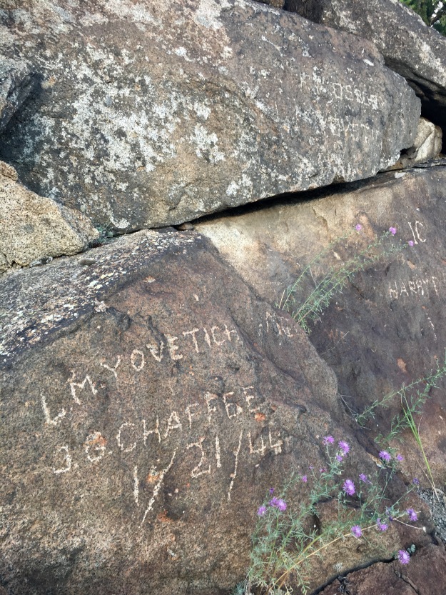
Along some abandoned tracks leading into Whitehall, MT we found a bunch of graffiti from the 40’s thru the 80’s including a hobo grave…


img_2062

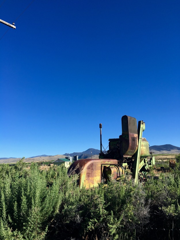
Boneyard, nostalgia for usefulness and hope of resurrection…

img_2041

Abandoned trestle walking. Harpo sez: “That’s terrifying. Not like a rollercoaster, where you’re like ‘Whee, terror!’ but ACTUALLY TERRIFYING.”


Map Party – Planning the Big Sky detour


Tim & Harpo folding & unfolding…


Harpo and I were looking for a challenge. Tho we have been enjoying the daily route finding and navigational challenges of the CDT, there was still somewhere we hadn’t gone – choosing our own route south, off the beaten path. So we decided, after several days of conversation, to try the Big Sky route.
Diverging from the CDT just after Butte, MT the route will take us south thru the Tobacco Roots and Spanish Peak mountains, the Gallatin National Forest and Metcalf Wilderness. We’ll end up traversing the northern rim of Yellowstone and making a long loop around the eastern side of the park, rejoining the CDT at the southern entrance.

We’re not the first, and I’m sure not the last to attempt this reroute. The Onion originally mapped it during his yo-yo in 2007 and others have documented variations. Tim at the Base Camp outfitter in Helena, MT was integral in helping us get the right maps and understanding the country.

 So using two anecdotal tales and three maps, we’ll head south into the less known!

Harpo’s CDT Journal #3


July 16
14 miles 
Yes! A townfood Bfast of mixed baby greens, avocado, also peaches & bananas! 
Then, Free wifi outside library by the awesome town park where they allow free camping. And today there is a flea market (and tomorrow a fiddle-fest.) Lincoln is one cool little town. 
Near the park we start hitching and within minutes two charming locals swoop us up. Tammy and Craig recently retired to their cabin here, and give us a ride 15 miles up to the pass even though it is 30 miles out of their way round trip. What sweethearts!
We hike 13 miles with much discussion about route finding and the patriarchy of internet trolls judging what real thru hiking is. What is thru hiking about when it’s choose your own adventure? Duration? Miles? Pleasure? The destination? The militant satisfaction of following a particular government-ordained route without variation (no thanks).
I’m on a deadline for this hike because of a family obligation in mid-oct. realistically, I can’t finish the whole route in 3.5 months. To do so would mean hiking 30 miles every day and no days off. So I have 4 choices: 1) traditional CDT routing thru Idaho and Wyoming and end somewhere in Colorado. 2) make my own route thru southern Montana to Yellowstone skipping the Idaho section, thereby “saving” 250 miles and a few weeks so I can maybe finish closer to the CO/NM border; 3) screw the idea of a continuous footpath and hike select sections along the trail until early October; 4) try to fly back after the engagement and finish in the approaching cold winter breezes. Groucho wants to hike with me and I with him, but he’s still committed to a continuous foot path of some kind. We spend a long time weighing options until we develop bickering emotional headaches attempting to stare into an unknown future. 


These conversations also make me realize I am homesick… but in a new way. Not for particular friends or family… I’ve been connecting with people when I need to and the Interwebs and wifi make that a lot easier, (especially now that my network extends from Finland to Guatemala to Virginia to Washington to Spain to Colorado to Austria to Hungary to Alaska to California to New Jersey and Oregon.)
Instead I realize I’m homesick for a sense of steadiness. For a mooring of place in this space-time continuum. It might be time to settle down for a minute. A theme that will pervade my thoughts these coming days and weeks. 
At dusk, we descend to flesher pass where a trail angel – Marc -cached water earlier in the week. There’s more than a gallon left so we top off with 1/2 liter each. 1/4 mile from the pass we find a trail head with a privy, a PICNIC TABLE and a flat spot to sleep. 


July 17

28 miles
A difficult morning. Still coming down from townfood-induced sugar high – and needing to dig multiple cat holes because of bad greasy food invading my gut – my emotions and systems are all outta whack. Also we are trying out hiking with treking poles again because of the steep descents, weak ankles, slippery fords and handiness of an extra leverage point when setting up our tarp. But this morning Groucho takes a dramatic fall/face plant tripping with his pole and though he appears uninjured, he fumes all morning. 
Thankfully the terrain is smooth and flowing, and though it’s long distances between water sources, the hours and miles pass quickly. 
We meet two rad section hikers Mango and Ron whom we will leapfrog with most of the day. It’s sunny, but cool at high elevation and in the trees. 


We climb a big hill and run into an older gentleman from Marysville with his pup. I am disarmed by his sparkling grey eyes and clear desire to connect with us, however briefly. He carries a pistol in his belt, water on his back and bearspray in his hand. 
We crest the climb, faced with a route choice, take the new CDT route over the mountain and see views at the observation tower, or take an old ATV road to a water source and bypass the peak. We opt for water and find it 30 minutes later with jeeps and motorbikes blazing by us on the dusty descent. The water hides in a lush gulch and bursts from the hillside cold and clear. We fill up our bottles. Why is water so heavy?!
10 minutes later we hit the CDT again and continue winding ever-southward and now… Upward. Our big climb for the day up up up to 8400 feet – black mountain. I’m tired and my calves burn, even with my new treking pole assistant “tripod.” We haven’t had a day off hiking since we began two weeks ago. Our shortest day was a 13 miler and my body lets me know as I trudge up the hill. We reach a tick infested grassy meadow where the trail disappears but we know we must continue up the ridge ahead. As we do dark clouds blow in from the East hanging on the side of the mountain in front of us. Then wind, then low thunder in the distance. 
“so Groucho, what if we get to the top of this treeless ridge and it starts lightning on us?” 
“We can descend to those trees in the East and throw up the tarp”


As we reach the steepest part of the climb the cloud speeds overhead. suddenly the thunder increases. We look at maps and realize our route would continue another mile uphill to the crest that lies before us. We can’t do that in this weather. We cut into the nearest set of living trees, off trail, and as it starts raining we throw up the tarp and crawl underneath. It’s 6:30pm. We sit and eat our hydrated dinners, pick tics off each other like apes, and chat as the thunder grows closer. Then heavy rain and hail pelt the cubanfiber above us. And we hi five. We are dry and electrocution-free. 
30 minutes later, two dry hikers emerge with a folded tarp, full bellies, and 2 hours of light left. The sky even looks blue ahead of us.  


We climb the ridge, then descend into a living, green, tree-filled saddle. So nice and sheltered here but still 1.5 hours of light! We press on, the sky – to the south ahead of us- so blue and clear. 
A half hour later we begin an ascent and look at the deadfall around us. Half the trees rotted, cracked, fallen, and mossy, probably infested with Western pine beetles. They usually invade sick and weak trees but – word on the trail – climate change and extreme high/low temps here have weakened all the trees and the mass infestation transforms the landscape … green hills turning ever to grey. It’s sad and dead and dry out here, especially on this ascent. The lack of leaves and thinning forest gives me a view to the SW where, *oh crap* dark clouds blaze toward us. 
We start looking for another sheltered place to bear down, but as thunder rumbles ever closer we see only dead and dead and dead trees. We make a run for it. A mile up steep switchbacks as lighting begins to glimmer to the near horizon. As we crest the hill the wind whips and thunder threatens. We’re at 8400 feet but there are some tall living trees around us. We feel unsettled but hopeful as we descend and begin to see larger patches of green. Finally Groucho spies a grip of trees where all the dead comrades already lie on the ground or at least against sturdier companions. We pitch our tarp and while lighting continues in the distance the storm moves away and we enjoy a dry night. 


July 18

22 ish miles to MacDonald Pass/Helena
We wake with 26 miles to go until we reach the pass which leads to Helena. Town Day. It’s a bit soon since we just left Lincoln but my cheapie rain coat failed last week and with all these storms I need a new one. Also we’re 80% commited to try the super cutoff route and hope Base Camp Outfitter in Helena will have maps we need. 
Our only water this morning is a spring in the middle of a cow pasture pouring into a cow trough. Thankfully it looks pretty clean but we definitely treat this one. 


Then we take a Ley map alternate that roams dirt forest roads. It cuts 4 miles off our day and meanders thru pretty pastures filled with black cows. We run into a real life cowboy rounding up cattle with his beautiful young pup. One bull has a lame leg and the cowboy emerges from the truck with a shotgun. We recoil in horror until he pulls the trigger. A dart hits the cow in the flank. It’s an antibiotic shot that will cure the hoof rot. 


The path is wide and clear but sunny so we don our sunbrellas. Instant cooling shade. 
We intersect the CDT at Mullen Pass. I find a penny on the trail and slip it into my pocket with a wish for good vibes the rest of the day. Then 8 miles to town, half uphill. It’s blazing hot and my face sports a sunburn despite my hat. My recently laundered shirt drenches in salty sweat and my calves/ankles/feet begin to protest. My mind wills them along “bed, hummus, shower, bed, hummus, shower”. 
As we near the crest of the climb, clouds swoop once again, another thunderstorm with lighting as we reach a bald. The white and brown cows here seem unimpressed, so I try to be too. With a little rain and hail following us, we race the last 3 miles down to the road. We arrive at a behemoth 4-lane highway with no shoulder on the hitching side and cars traveling 60 mph. Just as I despair, a car pulls out of the building at the trailhead and a window rolls down. The amazingly timed dude is headed to Helena and will give us a ride. The lucky penny is working!
Helena’s residents are rightfully proud of their mountain bike trails, their breweries, the Base Camp Outfitter, the Fire Tower coffee shop, and most of all The Bridge Pizza Joint. 
We spend an hour at the outfitter talking to Tim about our desired route and figuring out which maps best serve us. The man spills a fountain of knowledge. 

Then good groceries from Real Food a legit natural grocery and sleep at Budget Inn for $60 including tax.